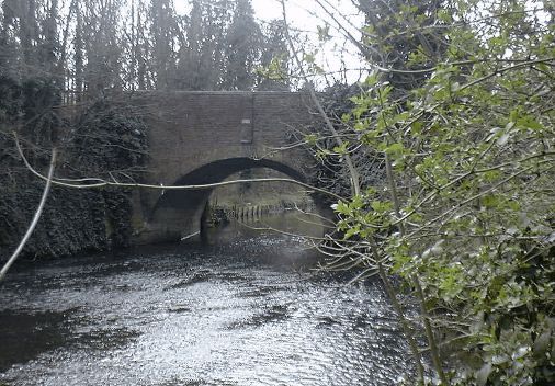
Baber Bridge
About 10 miles West of London
Baber Bridge - West of London
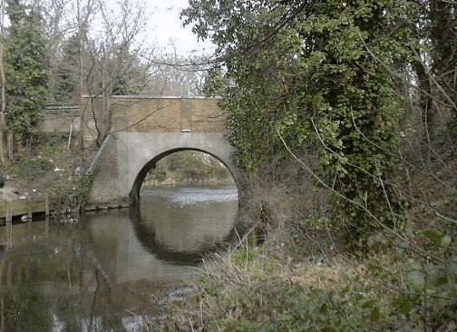
Photos courtesy of Nick Balmer
are Located in the Photo Album
This story is about the Roman Road and Baber Bridge. I've highlighted the part where the bridge is mentioned.
Nick Balmer has added the following:
I have lots more material which suggests that my Sunninghill Baber's were very involved in the 18th Century "re-discovery" of this road which ran very close to their property at Sunninghill. It headed into another property that they owned at Silchester which was the site of one of the very few Roman sites in England that was not used after the Romans left. It is therefore very well preserved underground.
It was excavated starting in Eighteeth Century when the Baber's owned some of the land on which it stood. John Baber who died in 1765 knew and studied with the Vicar of Silchester, who was involved in the earliest dig. This man, whose name is buried in my notes somewhere, eventually died when he drowned in the Fleet Ditch in London. This was one of the "lost" rivers that flow into the Thames and was a horrible open sewer at the time. It is thought he was fossicking for Roman remains and antiquities. What a way to go.
The entire article is at:
http://www.ukans.edu/history/index/europe/ancient_rome/(2) London to Silchester
The course of the road from Roman London towards Silchester has been noticed
as far as the original Watling Street at tsn end of Edgware Road (p.65).
From the Edgware Road the course continues on to Notting Hill along the line
of the Bayswater Road, which a parish boundary follows nearly all the way to
the Westbourne stream. There is then a slight change of direction, and
thence to Staines, 14-1/2 miles, the course of the road is so direct that it
is nowhere more than a quarter of a mile out of a straight line. It would
seem that from Notting Hill, on the edge of a terrace 95 feet above the sea
and overlooking the Thames valley, some landmark or beacon, on ground (175')
near Upper Bakeham to the south-west of Egham, was the point to which the
course of the road was directed. From Upper Bakeham the towers of South
Kensington and Westminster can be plainly seen, and the high ground at Upper
Bakeham must have been equally visible from Notting Hill before houses
obscured the outlook. From Notting Hill the Roman road followed this line,
which is the general course of the present high road until the latter turns
southwards towards Chiswick. Stukeley rode on by a narrow straight way to
Turnham Green, where to a discerning eye the trace of the road was manifest.
Parish boundaries, which have followed the present road all along, continue
straight on in the same line by Stamford Brook Road to Stamford Brook,
through Bedford Park, across Acton (Turnham) Green, and south of Acton Green
railway-station, to near Gunnersbury station, and then along the high road
again; and indicate the course of the Roman road to near Kew Bridge
railway-station. The straight line appears to have been departed from to
keep clear of the Thames, and through Brentford, and on nearly to Hounslow,
the course of the road is uncertain. It is probably followed by the present
road, curving nortwards near Spring Grove to avoid a stream. From the east
end of Hounslow lengths of straight road, almost in the same line, followed
almost continuously by parish boundaries, indicate that the present road
follows the course of the Roman road to Baber's Bridge. The Roman road
itself was uncovered by General Roy at the end of the eighteenth century on
Hounslow Heath, at the side of the modern road. For two miles on to East
Bedfont a parish boundary runs straight a little on the south of the modern
high-road, and then the latter, with a slight turn, goes straight to Staines
with parish boundaries along it for the last mile and a quarter. The
straight line crosses the Thames to Hythe a little to the south of the
present bridge, and near the site of the old bridge, to the west of which
Stukeley saw the old road very evidently go through the fields, the ridge
being then visible; but no sign of it now appears. He traced it along a lane
and a footpath towards Thorpe Lea.In 1835 the officers studying at Sandhurst made a survey of the Roman road
onwards to Silchester, and a memoir was furnished to the United Service
Journal. At Bakeham House, now called Upper Bakeham House, the substratum of
the road, and also the foundations of a building, and other Roman remains,
had then lately been discovered, proving apparently that the straight course
of the road had continued from Notting Hill to that point. In the valley,
nearly half-a-mile to the south of this line, a stone pillar erected near
Great Fosters in 1850 records that it marks the site of a Roman road to
Silchester, a portion of which remains in the adjoining meadow. If so the
road did not continue straight on, but bent to the south after crossing the
Thames; the pillar may however mark the site of a branch road. Beyond
Bakeham the memoir referred to states that the direction was through the
yard of the inn at Virginia Water, where according to tradition of
foundation of gravel, supposed to be the Roman road, had formerly been
discovered, and also that the line cuts Virginia Water, and that the ridge
could be distinguished for 300 yards, where one of the drives in Windsor
Forest ran along it. The yard of the inn seems to be out of a line across
any part of Virginia Water, and no trace of the ridge is now distinguishable
on to Belvedere, and the course of the road is uncertain.It is likely that the hill on which the Belvedere Tower stands (260') was
the point made for from Bakeham Hill, though it was perhaps avoided by the
road. Beyond, the course of the road lies in a straight line between it and
Duke's Hill, Bagshot (300'), the direction changing slightly, but the road
from Notting Hill to Duke's Hill is so nearly straight for 23-1/2 miles that
no part is as much as three-quarters of a mile away from a straight line
between those places. At Sunningdale the road is found in digging in the
allotments near the church, and it was until lately visible on by King's
Beeches, and by Chater's Pond, and to the back of Windlesham Hall, where the
county boundary marks the line of it for a mile and a half. Enclosing,
planting, and laying out the grounds of new houses have now however almost
effaced all trace of it. About a mile from Duke's Hill it is described in
1835 as being raised to a considerable height where it crossed a marsh.At Duke's Hill (300') there is a change of 27° in direction, and the road
goes nearly due west for 16 miles to Silchester. Under the local name of the
Devil's Highway, it passes over Easthampstead Plain in a straight line to a
point (311') called Crowthorne on the old Ordnance map, and then in nearly
the same line to Ridge Farm, Finchampstead (331'), and with a slight turn
southwards on by St. James' and West Court. On Easthampstead Plain it passes
a mile south of a large intrenchment called Caesar's Camp, between which and
the road, at Wickham Bushes, Roman coins and pottery are found. The Devil's
Highway is said by Bishop Bennet to have been raised with a trench on each
side, and to have been 90 e wide, which probably included the trenches. It
was levelled at the beginning of the last century when the ridings were cut.
In 1835 portions were still existing to the north of Finchampstead Church.
It crossed the Blackwater at Thatcher's Ford, and the river Loddon at
Stanford, near the north of Stratfieldsaye Park, and beyond that, Park Lane,
also called the Devil's Highway, with the county boundary along it for two
miles, runs in a straight line to the east gate of Silchester (Calleva).From Duke's Hill, Bagshot, to Silchester, 16 miles, no part of the road is a
quarter of a mile out of a straight line joining those places.From near Duke's Hill a Roman road has been supposed to have gone southward
to Frimley, Farnborough and Farnham, and the change in the direction of the
Silchester road has been thought to confirm the supposition, but without
much reason. Stukeley tells us that he traced a Roman road from Winchester
to Farnham and Farnborough, and which he supposed went on to Staines. He
says that between Farnham and Alton the bank was visible, and in several
places between Alton and Alresford. There appears to be no evidence of this
road.Silchester, on ground 300 to 320 above the sea, is in shape an irregular
polygon 820 yards from the east to the west gates, and 803 yards from the
north to the south gates. Outside the town walls are earthworks of uncertain
age. Five Roman roads converge to Calleva, approaching it in different
directions, and it cannot be doubted that it owed much of its importance to
its being the place where the road from London branched in many directions.The excavations carried on in recent years show that the street in
continuation of the road from Staines runs straight from the east gate to
the Forum, and a parallel street about 93 yards to the north of it leads to
the west gate. A street at right angles to these led from the north to the
south gate. The east and west gates consisted of two covered passages, 13
feet wide, separated by a middle pier, while the north and south gates had
only one passage of 13 feet.There was no doubt a road from Calleva northwards, but there is nothing to
show its course with any certainty, nor could Bishop Bennet trace it in the
beginning of the last century. Faint traces appear to have been observed in
1837 in a line between the north gate of Silchester and Ufton Church, and 25
or 30 years before that the road is said to have been traced by excavations
in that line for 800 yards. The modern road by Englefield to the ancient
ford across the Thames between Pangbourne and Whitchurch is a continuation
of the same line. The indications of a Roman road in this direction on the
west of the Thames through Streatley to Dorchester have already been noticed.
Email me if you can correct or add to any information on this page.
Please include the URL address from the window at the of top your browser.
Contact Baber Family Tree Return to Home Page
License of Limited Use: License is granted for you to use Content only for personal family history research, and you may use Content only as search results relevant to that research. The download of the whole or significant portions of any work or database is prohibited. Resale of a work or database or portion thereof, except as specific results relevant to specific research for an individual, is prohibited. Online or other republication of Content is prohibited except as unique data elements that are part of a unique family history or genealogy. Violation of this License may result in legal action for injunction, damages or both.
© Copyright 1997-2019. Baberfamilytree.org